

Here’s October’s first Mystery Monday photo! Can you believe its already October? Anyways, after reading our guidelines below, leave your observations as to what this photo could be and where it might fall on the map. The more descriptions and observations, the better!
Here are the guidelines:
- If you can correctly identify the photo with a link to Google Maps showing where it is, or should be*, you win! Leave a comment here on the blog or on our Facebook Page.
- Whoever identifies the photograph and posts a link to its correct location first wins!
- This week’s winner will receive a $50 coupon for any framed print, or simple bragging rights! Whichever you prefer!
If you know of anyone else who would enjoy this blog (or perhaps someone who would be a great competitor,) please send them here!
Let the games begin!
Visitor Comments
No legible signs to google (at least not legible to me), so we're gonna have to work for this one. I see a few minivans, so we're back in the mid to late 80s. Pretty flat terrain. Most of trees look like they were planted when the homes/buildings were built; so perhaps an area of the country that isn't naturally wooded (e.g. Plains states or central California); the trees in the foreground (which look native) are a bit scrawny, still supporting the Plains and central California hypothesis.
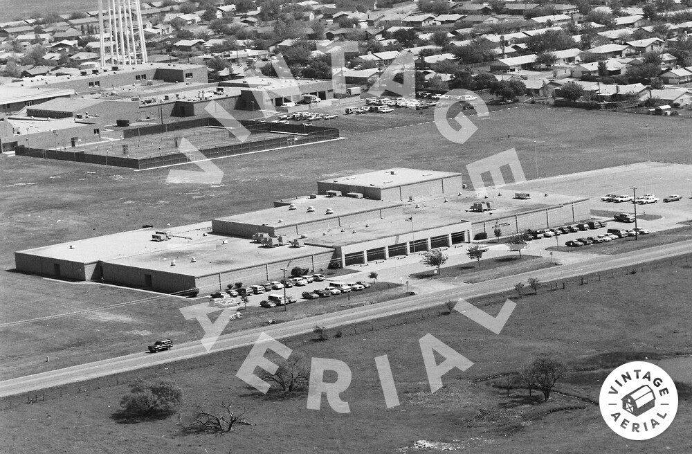
The building in the background is a high school. The fenced in area contains tennis courts and there is are school buses parked in the garage to the right of that.
The way the space is shared, I think the foreground building is connected. With no obvious play area, I do not feel it is an elementary school. More likely it is an administration building. There is a sign on the front face to the right of the flagpole and entrance.
I'll amend that. It might be a middle school since the tall section on the back right could be a gymnasium. And a middle school wouldn't necessarily have a playground. And there's enough parking for parents to the right side.
The high school / middle school idea was my first impression, too; primarily because of the tennis courts. It is odd, however, to have such a large garage area (or is it loading docks?) at a high school. Also, both of these large building complexes have very few windows; school buildings I'm familiar with have lots of windows in the classrooms (primarily because air conditioning is somewhat rare in schools outside the deep south). Still, what other type of facility would have six tennis courts like that?
Sorry, I wasn't looking closely enough. There are 8 tennis courts. I'm thinking the track / football / baseball facilities must be off to the left of this photo. If these are school buildings, then I suspect it either stays fairly warm for most of the school year, or it is often extremely hot at the beginning (late summer) and end (spring) of a traditional school year.
Could this be a minimum security prison?
I'm thinking Texas. But that's an awfully big state to wander around in. It'd be nice if the hint this week was county (or even first few letters of county name) ... even if this isn't Texas.
Texas is correct! Actually, we have some pretty exciting news for people in Texas. There will be another blog post up today or tomorrow about it.
Alright Tony, I'd say its time you tell us where it is!
Linda, I also thought the nearly windowless buildings were reminiscent of a prison. However, I believe even a minimum security prison would have fences surrounding the buildings.
Anyway, I have had enough time to wander through Texas. I ruled out the far western and coastal regions of Texas, and focused on counties which a Discover Your Photos search indicated there were photos from the mid 80s. Fortunately for me, I started with those counties which showed images from 1985. Unfortunately for me, I started with "A". So it took a while.
This is Crowley High School (background buildings) and Crowley Ninth Grade Campus (foreground building), in Crowley Texas (about 12 miles SSE of Fort Worth).
Google Maps: http://maps.google.com/?ll=32.576499,...
Google Earth: http://awcolley.com/awcolley.com/pmwi...
In Google Earth, view the 1995 imagery and you can see the area south of the Ninth Grade Campus (i.e. in the very foreground of the photo) before the subdivision/development replaced that pond and scattered native trees.