

Welcome to this week’s Mystery Monday Contest! After reading our guidelines below, leave your observations as to what this photo could be and where it might fall on the map. The more descriptions and observations, the better!
Here are the guidelines:
- If you can correctly identify the photo with a link to Google Maps showing where it is, or should be, you win! Leave a comment here on the blog or on our Facebook Page.
- Whoever identifies the photograph and posts a link to its correct location first wins!
- This week’s winner will receive a $50 coupon for any framed print, or simple bragging rights! Whichever you prefer!
If you know of anyone else who would enjoy this blog (or perhaps someone who would be a great competitor,) please send them here!
Let the games begin!
Visitor Comments
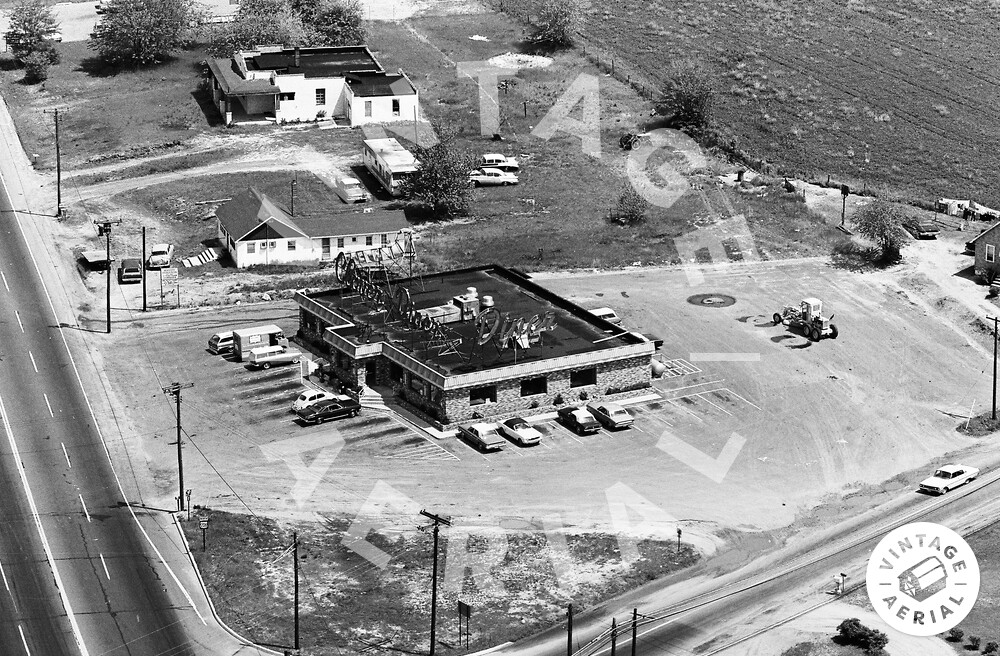
SLUG BUG! No returns! (I just punched you in the arm). Awesome clues in this photo (and, no, I haven't found it yet).
The wikipedia page for Slug Bug is actually titled "Punch Buggy!"
http://en.wikipedia.org/wiki/Punch_buggy
I've never heard anyone call it that, but perhaps I'm just young.
Anyways, I think this is a great photo. The sign on the restaurant seems like a big giveaway, but its not!
Does that say Claire's Diner? The highway sign is probably a US highway, but I can't read the #. Might also be an Ohio state highway shield. The field top right makes me think more plains / west. Knowing you don't do Colorado, I would pick Nebraska, Kansas, or Oklahoma.
I've done a bit of image processing, specifically to simulate shifting the perspective of the photo to view the sign more square-on; the result is http://awcolley.com/awcolley.com/pmwi... Anyway, it looks to me like "Clover Diner".
I'd say this photo is from the early-mid 60s, and the state it's in apparently required front license plates (at least back then).
I'm with Andrew, I cannot tell whether it's a US highway sign, an Ohio state road sign, or something else; but it kind of looks like the first digit is "7".
I'm not having any luck making out the route number, though I'm beginning to lean more toward a US Highway. I am sure it is neither US 701 nor US 72, because I checked all the counties along those routes; only one had rolls from the 60s and this frame was not on any of those rolls.
Hard to tell from this close up, but it appears like fairly flat terrain here; and the dirt is very light colored (perhaps sandy). The trees are not very big, so perhaps a drier climate (or maybe just prone to hurricanes).
Tony, I thought your hurricanes observation was brilliant. I'll confirm that.
After finding lots of places where this photo wasn't taken, I can finally say this is not in a state typically associated with hurricanes -- though they do happen here: Donna 1960, Belle 1976, Gloria 1985, and Irene this year. Nor'easters (sometimes with hurricane force winds) are more likely here.
BTW, the first digit of the US highway number turns out to be a "2" (which when blurred is easily confused with a "7").
If I'd stuck to my guns about the front license plate observation, I could've saved myself lots of skimming through film rolls; this is in one of the 31 states that require them. However, that time spent was not totally in vain -- I did add quite a few churches to my "churches found on Vintage Aerial" list at http://awcolley.com/Main/VAChurches
This is now the Esquire Diner, at the intersection of US 206 and Monmouth Road, about 3 miles northeast of Mount Holly, NJ. The huge neon signs on the roof are gone.
Google maps: http://maps.google.com/maps?hl=en&...