

Last month, my colleague and Director of Engineering, Kevin Marsh, wrote a post giving a broad overview of how Vintage Aerial uses technology to preserve history. As Director of Archive Development, I have the privilege of working with the ornate, historic film in our vault and the ground-breaking software that Kevin has developed. While I could go on and on about the details of this work, this post will focus primarily on the G.I.S. (Geographical Information Systems) aspect of my job.
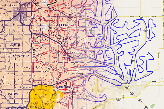
Years ago when a pilot would go up to take photos, he would bring a simple county map with him. While flying and taking photos, he would also trace his flight path on these maps and mark the spot each time he changed a roll of film. Let me remind you, he did this all while flying!
Today, we use those same maps to locate the placement of each individual roll. The maps are scanned in a high resolution, with file sizes reaching 300mb, and stored as a TIFF file on our server. This is where the G.I.S. work comes in. With the TIFF file of the original map and the geocoding features of Google Maps, we are able to geo-reference correlating x and y points of the original map to longitude and latitude points of Google Maps. The outcome is a geocoded map layer allowing us to use the functionality of Google with our maps. Once this is complete, it is time to geocode each individual flight path. I do this using a wonderfully simple web application we’ve developed. I trace the flight path using my mouse and a series of clicks along the way.
As I drag my mouse over the map, I often imagine the pilot flying over the county taking these beautiful photos, and as I click to start a new roll, I see the pilot changing rolls of film in his camera; the two of us preserving history together through aerial photography.
When a flight path is geocoded, it is automatically and digitally paired with a roll in our database. The end result? An innovative yet simple way to search for your family’s history. We hope you enjoy it!
Jordan Justice, the Director of Archive Development at Vintage Aerial, is a newly wed in a perilous pursuit to find the location and story of every photo in the archive.