

Welcome back to another Mystery Monday! This week’s photograph is most definitely a change of scenery and the exact location is unknown. We know the state and county, but its up to you to find it on Google Maps! I’ll provide a hint later in the week if no one is having any luck finding it.
If you’ve been playing for a while, then you know how this works. If not, be sure to read the guidelines below.
As always, the more descriptions and observations you leave, the more fun Mystery Mondays are!
Here are the guidelines:
- If you can correctly identify the photo with a link to Google Maps showing where it is, or should be, you win! Leave a comment here on the blog or on our Facebook Page.
- Whoever identifies the photograph and posts a link to its correct location first wins!
- This week’s winner will receive a $50 coupon for any framed print, or simple bragging rights! Whichever you prefer!
- In order to win, the photo must be revealed by this Friday at 5:30PM EST.
If you know of anyone else who would enjoy this blog (or perhaps someone who would be a great competitor,) please send them here!
Let the games begin!
Visitor Comments
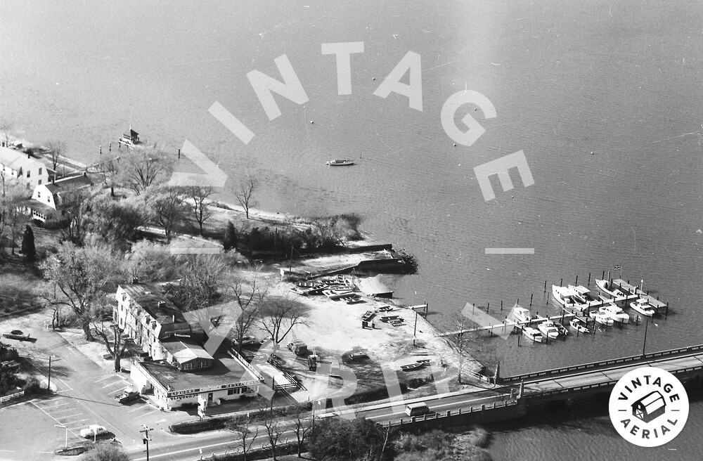
Many trees have no leaves, but a few do, so this was taken in mid-fall. Vehicles make me think this was taken in the 60s. Can't really see the front of any vehicles enough to tell if they require license plates on the front or not. Unfortunately, the sign by the road is overexposed, so we have no name to google. The fact that "liquors" are sold mean this wasn't in a "dry" county. The water is very calm, so this is most likely along a lake, river, or sheltered bay.
I think perhaps the biggest location clue may be the architecture. The inn(?) attached to the restaurant has a mansard roof; while the two homes in the background have gambrel roofs. According to what I've read online, both of those roof types are most commonly found in the Northeast.
Hmm, I was thinking the trees looked southern, so I thought we had ourselves a big wide river like Virginia / North Carolina. The long piers out to the dock seem to indicate a shallow muddy shoreline. But I suppose those could be found in either the southeast or northeast.
The bridge is an interesting style, and given the age of the photo, I would not be at all surprised to find a modern four-lane bypass bridge nearby, with this bridge converted to a fishing pier or chopped off at the shoreline.
Well, if this is in the Northeast, it's in ME, PA, or NJ. I've ruled out NY, VT, NH, MA, CT, and RI (assuming this was taken in the 60s).
Hey Lance, we need a hint! (well, at least I do, I suppose I shouldn't presume to speak for everyone)
BTW, I've now also ruled out NJ, MD, and DE.
Well don't rule out Maryland, because that's where this is! :)
Well, I can't find it. Is this somewhere on the Chesapeake?
Alright, I got one! Man there are a lot of inlets, bays, and rivers in Maryland. But maybe I had an advantage growing up along the Patuxent between Baltimore and Washington.
Our over-exposed sign says "Riverview Liquors" and this is across the river from Chestertown, MD.
Aerial view here: http://bit.ly/uH6lpv
Streetview of our building: http://bit.ly/uH6lpv
Andrew! Great job! I'm so glad someone solved this one.
Man, I looked at that roll -- http://vintageaerial.com/photos/maryl... -- several times; though it was always after looking at several rolls from other counties ... so my excuse is my eyes were going bonkers by then :).
Great job, Andrew!