2018

Georgia: Empire State of the South

Posted on 11/02/2018 by Nathan Lewis in New Content Releases

Georgia Monument located at Chickamauga Battlefield in Poe Field. Part of the Chickamauga & Chattanooga National Military Park.

Today, we are excited to announce that more than 585,000 aerial photos of Georgia are now available to search and view online. Georgia was named for King George II of England, it was founded in 1732 by a British Member of Parliament James Oglethorpe as a felon colony. Oglethorpe wanted to use the colony as a place for prisoners who could not pay their debts. The social reformer believed that many debtors were released back into cities without any form of support. He wanted to take these people and give them a second chance in a new place.  Georgia is often called the Empire State of the South and is also known as the Peach State. Georgia is the largest state east of the Mississippi River, the Okefenokee Swamp encompasses over 400,000 acres of canals; moss draped cypress trees, and lily pad prairies providing sanctuaries for hundreds of species of birds and wildlife including several endangered species. The beautiful landscape can be seen at the annual Masters Golf Tournament which is played at the Augusta National in Augusta every first week of April. the event was created after the club was denied as a venue for the US Open. There are some odd laws one should keep in mind while in Georgia as you might be breaking them unknowingly, Carrying ice cream in your back pocket on Sundays is against the law. There is also a law stating you cannot spread a rumor if it is false. You are not allowed to hook a giraffe to a pole or street lamp in Georgia and in Gainesville, the Chicken Capital of the World it is illegal to eat chicken with a fork.

Georgia was the last of the original 13 colonies and the 4th state to join the Union in 1776. Georgia was the first colony to produce cotton commercially, first planting it near Savannah in 1734. In 1828 Auraria, near the city of Dahlongea, was the site of the first Gold Rush in America. Wesleyan College is the birthplace of the first sororities as it became the first college in the world to grant degrees to women in 1839. In 1861 Georgia became the 5th state to join the Confederacy. Chickamauga and Chattanooga National Military Park safeguards the sites of two major battles of the American Civil War: the Battle of Chickamauga and the Chattanooga Campaign making it the site of the bloodiest battle in American history. Coca-Cola was invented in May 1886 by Dr. John S. Pemberton in Atlanta. The name “Coca-Cola” was suggested by Dr. Pemberton’s bookkeeper. At present, the headquarter of Coca-Cola is in Atlanta. Atlanta is known as the birthplace of the Civil Rights Movement; you can find Martin Luther King Jr.’s house on Auburn Ave. In 1945, Georgia became the first state to lower the legal voting age from 21 to 18. The 1996 Olympic Games were hosted by Atlanta, and the games were certainly the largest as a record 197 nations participated in the Games.

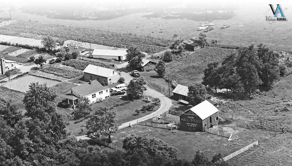
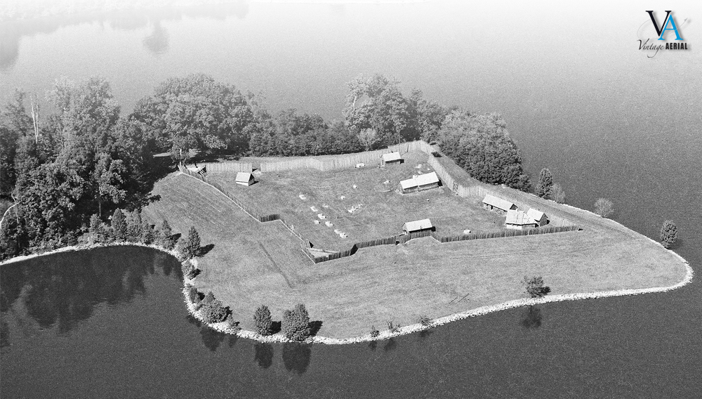
It’s no wonder that Georgia is an agricultural powerhouse, considering the diverse topography and climate of its 10.1 million acres of farmland. This land covers 28 percent of the state and ranges from coast to mountains, making it ideal for the production of a variety of agricultural commodities. There are 47,800 farms averaging 212 acres, one in seven Georgians is employed in agriculture, forestry or related fields. Georgia’s annual $13 billion farming value is composed of some top commodities, including broilers (chickens for meat), cotton, chicken eggs, vegetables, melons, peanuts and more. Poultry and eggs contributed $5.4 billion to Georgia’s total farming value, and more than two-thirds of Georgia’s counties are involved in poultry production and processing. Our collection has aerial photos of many of these farms dating back to 1977!

We invite you to come and take a look at these homes and farms in our collection of more than 585,000 aerial photos of this great state. Home is the place where you became you. Find your way back!

When searches get difficult

Posted on 10/12/2018 by Lance Roper in Company Updates

We’re kicking off a short series to provide some pro-tips for identifying photos in our collection. To begin, we’ll talk about where these photos came from and the various factors that come into play when some users experience difficulty when searching for a specific photograph.

Way Back When

In the early 1950s, cottage aerial photography businesses began to form around the country. Their goal was to photograph rural homes and farms and sell framed enlargements door-to-door. They started by hiring pilots to take photographs of areas they thought to be ripe with prospects.

The pilots created flight path maps and marked their location mid-flight each time they took 35-37 pictures, or consumed a roll of film. As soon as their film was developed, a salesman could begin peddling framed enlargements using the map as a reference to the location of the film.

A snippet of an original flight path map.

West Virginia: Montani Semper Liberi

Posted on 09/07/2018 by Nathan Lewis in New Content Releases

Outdoor advertising had its origin in Wheeling about 1908 when the Block Brothers Tobacco Company painted bridges and barns with "Treat Yourself to the Best, Chew Mail Pouch."

Today, we are excited to announce that nearly 385,000 aerial photos of West Virginia are now available to search and view online. West Virginia is nicknamed the Mountain State and the motto is “Mountaineers Are Always Free” sometimes displayed as the Latin phrase, Montani Semper Liberi. The state was named in honor of Queen Elizabeth of England. Tourism is the state’s leading industry. For many years, coal was the leading industry.

West Virginia is considered the southern most northern state and the northern most southern state. Because of its location, West Virginia played a major role in the Civil War. Bailey Brown, the first Union soldier killed in the Civil War, died on May 22, 1861, at Fetterman in Taylor County. Weeks later the first major land battle in the Civil War, the Battle of Philippi, was fought between Union and Confederate soldiers on June 3, 1861. Two years later West Virginia was admitted to the Union on June 20, 1863, by a proclamation signed by President Abraham Lincoln.

On February 14, 1824, at Harpers Ferry, John S. Gallaher published the “Ladies Garland,” one of the first papers in the nation devoted mainly to the interests of women. This focus on women’s rights and interests continued throughout West Virginia’s history. On May 10th 1908 the first Mother’s Day was observed at Andrews Church in Grafton. A bit on the darker side but still an important change in the women’s rights movement was the first federal prison exclusively for women in the United States opened in 1926. In 1928 Mrs. Minnie Buckingham Harper was the first African American woman to become a member of a legislative body in the United States.

West Virginia has a total of 3.7 million acres of farmland, consisting of around 23,000 farms averaging in size of about 157 acres. West Virginia’s Agriculture industry has an economic impact of $806 million dollars per year. Hay, grown to feed the state’s livestock, is the #1 crop, providing 2% of West Virginia’s total agricultural receipts. Broilers (young chickens) are the state’s #1 agricultural commodity, generating about 31% of West Virginia’s total agricultural receipts. Other major crops of West Virginia are apples, peaches, soybeans, and tobacco. Our collection has aerial photos of many of these farms dating back to 1973!

We invite you to come and take a look at these homes and farms in our nearly 385,000 aerial photos of this great state. Home is the place where you became you. Find your way back!

Maryland: America In Miniature

Posted on 05/25/2018 by Nathan Lewis in New Content Releases

Fort Frederick State Park Annapolis MD, This fort served as Maryland’s frontier defense during the French and Indian War.

Today, we are excited to announce that nearly 250,000 aerial photos of Maryland are now available to search and view online. Maryland is often referred to as “Little America” and a great deal of our early history as a nation took place right here. In 1696 the King Williams School opened which was the first school in the United States. During revolutionary times Rockville was known as “Hungerford’s Tavern” the name of its most familiar landmark. One of the first calls to freedom from British rule was heard at the tavern in 1774. Maryland is one of two states which gave up some of its lands to help build the nation’s capital of Washington, D.C in 1790. Throughout the years there were a plethora of stories that directly contributed to forging a nation free from British rule. This is one of my favorites, On the morning of August 10th, 1813 residents of Saint Michaels having been forewarned of a British attack, hoisted lanterns to the masts of ships and in the tops of the trees. The height of light caused cannons to overshoot the town. This first known “blackout” was effective and only one house was struck and is now known as the “Cannonball House.” One year later America’s national anthem was written by Francis Scott Key. It is believed Key wrote the anthem on September 14th, 1814 while watching the bombardment of Fort McHenry in Baltimore Harbor.

Maryland’s little-known nickname, “America in Miniature” comes from its agriculture being as diverse as that of the nation itself. As the state has grown in population, traditional dairy, grain, and livestock production, while still active, have given way to products more directly related to consumers. Poultry, nursery and turf production, seafood, dairy, corn, soybeans, racing and pleasure horse industries now dominate Maryland agriculture. 40% of its land is in agriculture covering over 2 million acres. This area is split into nearly 13,000 farms averaging about 160 acres each. Approximately 350,000 people, including nearly 6,000 full-time farmers, are employed in some aspect of agriculture, making it the largest commercial industry in Maryland. This agricultural industry contributes more than $17 billion in revenue annually. Many of these farms, home, and businesses that have contributed so much to Marylands economy and culture have been preserved in our collection.

We invite you to come and take a look at these homes and farms in our nearly 250,000 aerial photos of this great state. Home is the place where you became you. Find your way back!

Virginia: The Old Dominion

Posted on 04/06/2018 by Nathan Lewis in New Content Releases

The 1987 classic film “Dirty Dancing” was filmed almost entirely at the Mountain Lake Lodge in Pembroke, Virginia

Today, we are excited to announce that over 745,000 aerial photos of Virginia are now available to search and view online. Virginia is known as “the birthplace of a nation” nicknamed “Old Dominion”. It was named for England’s “Virgin Queen,” Elizabeth I. Virginia was the 10th state added to the union and has a long history. Contrary to the common story of the famous dinner with the pilgrims, the first Thanksgiving actually took place here in 1619. With ocean access and a centralized location, almost dividing north from south, Virginia has seen the worst of the wars in our country. Patrick Henry made his “Give me Liberty or Give me Death” speech in St. John’s Church in Richmond. Eight years later The American Revolution ended with the surrender of Cornwallis in Yorktown. During the Civil war, Virginia was the site of more Civil War battles than any other state, with more than 120 major battles being fought here. That’s an average of one major battle every 12 days. Today Virginia is the “Internet Capital” with estimates that 50 to 70 percent of all Internet traffic flows through data centers located in Northern Virginia. In fact, the images you see at Vintage Aerial are served from Virginia within Amazon’s data centers there.

Jamestown, the first of the original 13 Colonies was founded for the purpose of silk cultivation. After blight fungus destroyed the mulberry trees sericulturist planted tobacco as a cash crop. Today agriculture is Virginia’s largest industry by far! The industry has an economic impact of $55 billion annually. This agricultural production is one of the most diverse in the nation. Many of Virginia’s commodities and products rank in the top 10 among all U.S. states. These include tobacco, apples, grapes, peanuts, tomatoes, and cotton. Virginia has 44,800 farms with an average size of 181 acres. Farms cover 8.1 million acres about 32 percent of Virginia’s total land area. Amazingly, Nearly 90 percent of Virginia farms are owned and operated by individuals or families. 17% of these primary farm operators are female. With this long history of family-run farms, we hope to have preserved this history and the memories attached to them in our collection.

We invite you to come and take a look these homes and farms in our over 745,000 aerial photos of this great state. Home is the place where you became you. Find your way back today!

Tennessee: The Meeting Place

Posted on 01/12/2018 by Nathan Lewis in New Content Releases

Fort Loudoun, Built by the British in 1756 during the French and Indian War

Today, we are excited to announce that over 323,000 aerial photos of Tennessee are now available to search and view online. The name “Tennessee” originated from the old Yuchi Indian word, “Tana-see,” meaning “The Meeting Place.” Tennessee is nicknamed “The Volunteer State” which it won during the War of 1812 when volunteer soldiers from Tennessee displayed great valor in the Battle of New Orleans. There is a very old and rich history here, far too much to cover in this short blog. The city of Bristol is known as the birthplace of Country Music and if you listen to Country then you know Nashville. Nashville’s Grand Ole Opry is the longest continuously running live radio program in the world. It has broadcast every Friday and Saturday night since 1925. Nashville is home to 341 recording studios and nearly 40 percent of the entire music industry is concentrated in Los Angeles, New York, and Nashville. The music made in Nashville contributes a whopping $9.7 billion within the Nashville metropolitan area.

Another major stop in Tennessee is the city of Memphis. Elvis Presley’s home called Graceland is located here and is the second most visited house in the country. Every year I take a short road trip and the last two years were Nashville and Memphis. In Memphis, we enjoyed the nightlife on Beale Street and ate some of the best BBQ I have ever had at Central BBQ. We took the Gibson Guitar Factory tour where they still hand make each guitar just as they did when they first started, this was an amazing experience.

While most commonly known for its music and history Tennessee has a strong backbone in agriculture. Tennessee farming is far from the mule-and-plow stereotype of the past. By keeping up with the technological times and embracing sustainability, agriculture and forestry have remained vital sectors in the Volunteer State, contributing $74.8 billion to Tennessee’s economy each year. Leading agricultural commodities are cattle and calves, broilers and milk, and also soybeans, corn, hay, wheat, cotton, and tobacco. With just over 67,300 farms spread across 9 million acres of land Tennessee contains many prosperous traditional farming operations. More than 349,000 Tennesseans are employed in both the agricultural and forestry industries. We invite you to come and take a look these homes and farms in our over 323,000 aerial photos of this great state. Home is the place where you became you. Find your way back today!