Technology and History are almost contradictory. Often we hear news stories of a new technology coming along and eradicating the past. We certainly recognize the theme in the story of our photographic collection. Modern “progress” in the form of shopping malls, corporate farms, and urban sprawl are encroaching on rural America as many of us remember it. But the beauty of Vintage Aerial’s product and service is that today’s advanced digital imaging, GIS, and web technology are combining to preserve the past.
Digital Imaging
At the heart of our collection are the photographs. But the photos shot from the 1960s to even the late 1990s were shot on (black and white) film, and live in a protected vault of film canisters.
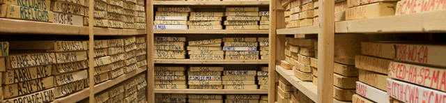
We’re scanning and digitizing some 700,000 rolls of this film. Each image is stored as a lossless-compressed TIFF file that is around 6 megabytes. When we’re finished scanning, the the total collection will take up about 150 terabytes.
GIS (Geographic Information Systems)
Because our photos are of specific locations and our pilot photographers captured those locations in paper flight maps as they flew, advancements in GIS (geographic information systems) have made it possible to find a few digital images in a specific location out of our archive of 25 million.
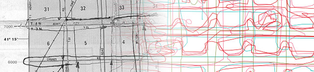
With a fusion of open source and proprietary software, our archive development team transforms paper flight maps into digital, georeferenced data. We then use geocoding services from Google to transform an address into its approximate latitude and longitude coordinates. Where the two intersect lies a digital photograph that captures a specific place at a specific time in history.
Web Technology
I use open source languages and frameworks like Ruby and Ruby on Rails to power the web site you are viewing now, which allows you to share our photos with the world. I’m building tools that enable more interaction with the collection. And by tagging, commenting, and sharing stories about the photos we’re creating something that goes way beyond film in boxes!
We currently have about 300,000 photos in 30 counties online, but we’re working to bring our entire collection online, one roll of film at a time.